Choose your language!
Deutsch 
English 
Français 
Lëtzebuergesch 
Português 
Slovenčina 
ABOUT
MapPy is an interactive pedagogical tool conceived to help children learn basic political geography in an entertaining way.
For portability, it has been conceived as a web application. Only a web browser and an internet connection are required, but a large screen is also recommended.
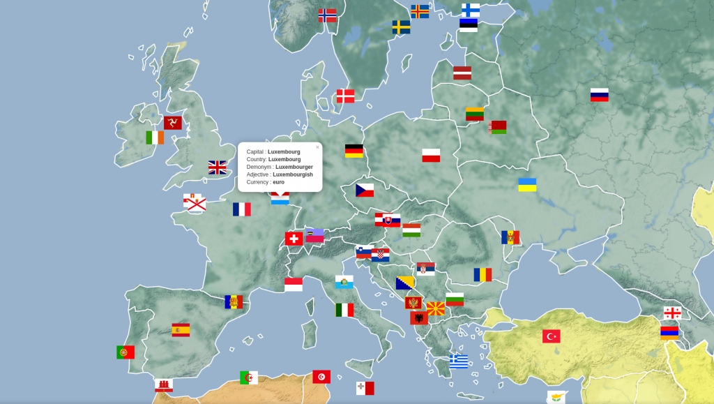
It is a world map with country flags centred on the coordinates of the capital cities. Clicking on the flag reveals information about the country (name of the country and the capital, demonym, adjective and currency). The countries are coloured according to the continent they belong to. Hovering over their area highlights the country borders whereas clicking on the country causes the map to be zoomed and centred on it. Furthermore, transparency enables to appreciate the geological features.
Six languages are currently provided: English, French, German, Luxembourgish, Portuguese and Slovak.
USE AS A QUIZ OR GAME
We propose the following possible usage: Individual players or teams point to a flag and the competitor player or team is required to enunciate the name of the country and its capital. They receive one point for each correct answer. After a number of rounds, say ten, the player or team with the highest score wins the competition.
SOURCE CODE
The Python 3 source code used to generate the HTML files is freely available here.
ACKNOWLEDGEMENTS
Our wholehearted gratitude to the Zenter fir d’Lëtzebuerger Sprooch (ZLS). Their help with the Luxembourgish version makes this resource more relevant, complete and unique.
CAVEATS
The colour of the country depends on the continent its capital city lays on (for instance Russia is entirely coloured blue, which is the colour that corresponds to Europe, including its Asian regions). The Australian continent and the Pacific islands which do not fit within the seven-continent paradigm have been grouped together as Oceania. Many non fully sovereign territories have been included, but not all, which may be confusing. We may trim them at some point.
The maps are automatically generated by a couple of Python scripts. If you spot any error, please, let us know.